Looking for your apps? Click the account icon in the upper right corner of the page.

Going With the Flow

Hero Image

Drawing upon the strengths of GNSS technology, Ajax Paving introduces the state’s first continuous flow intersection

Who hasn’t sat at a busy intersection cursing their fate as they wait through another light cycle, all the while mumbling about how commercial space flight will soon be possible, yet effectively dealing with traffic flow remains an impossibility? Those of us who have, can now rest assured that a solution to this vexing problem does, in fact, exist and the latest example of it is taking shape just outside of Ft. Meyers, Florida. There, Ajax Paving Industries of Florida is in the early phases of building the state’s first Continuous Flow Intersection (CFI), a unique approach to traffic management that has already proven successful in other areas of the country. And, while most companies would see tackling such a major, high-profile, job as sufficiently challenging, Ajax has chosen to employ GNSS technology throughout the project, effectively doing it stakelessly. Sit tight a little longer, Ft. Meyers, relief is on the way.

There and Back Again

To understand why the intersection of SR-82 and Daniels Parkway was the ideal candidate to debut the first CFI in Florida, one need only see the exodus of vehicles leaving the city of Lehigh Acres every morning, then heading back in every afternoon. According to Jacob Amann, Ajax Paving GPS specialist, backups, extending for a couple miles are not uncommon, resulting in regular delays, lost productivity and L.A.-like stress levels.

“During peak periods, cars are literally pouring out of or into Lehigh and the intersection of SR-82 and Daniels simply wasn’t built to handle that load,” he said. “Florida DOT looked at a number of possible solutions to the problem, but liked what the CFI offered in terms of keeping more traffic moving at any given time.”

A new concept to all but a few parts of the country (Louisiana, Utah, Texas, and Missouri), a continuous flow intersection is a highway engineering design which seeks to minimize drivers’ time spent in the left turn lane waiting for other segments of the intersection to cycle through their phases. Instead, cars wanting to turn left are siphoned away into a lane referred to as a “bay,” beginning 600 feet before the intersection, and simply make their left turn when oncoming traffic get a green light to go straight. By eliminating the wait for a green arrow, traffic turning left is segregated from those vehicles heading straight — without the need for a ramp, bridge, or fly-over. Right turns will be handled in right lane slip lanes that merge with the main lane downstream of the intersection. The net result is through-traffic gets more “green time” and capacity through the intersection is dramatically increased. In fact, in a CFI, 70% of traffic is moving at any given time.

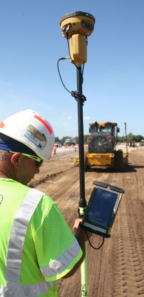
“As high-profile as this project is, our owner and upper management still felt it was the right job to put our GNSS skills to the test,” said Amann. “We made that commitment — and then some — and the results have been impressive. This is a two-lane road increasing to four lanes then up again to six. The maintenance of traffic alone could be a nightmare, so we’ve created models for all the traffic switches, and then used the GNSS-equipped dozers and graders to make it all happen.”

Curb: the Enthusiasm

Fulfilling its vow to go “all-in” on the CFI job, Ajax utilized GNSS technology in virtually every facet of the project, including tracking quantities from a nearby borrow bit, milling the existing surfaces, and doing it all without pounding a stake. They then took it a step further.

“We actually made it a prerequisite for our subcontractors to embrace GNSS and that wasn’t always an easy request to fill,” said Amman. “But, in doing so, we found the companies who recognize the value these solutions bring to the jobsite. Ft. Myers-based Tincher Concrete Construction, who did all of our curb and gutter work, is one of those companies. They had no prior GPS experience, yet they’ve been able to hit the ground running and have posted some impressive production numbers. The same holds true for other subcontractors as well.”

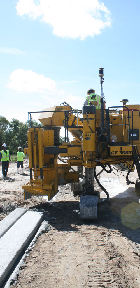
From the point of view Tincher Concrete, the initial move to GNSS was fraught with uncertainty. Stringline is, after all, the visual reference upon which concrete paving professionals have grown to rely. Remove that, it’s been thought, and nothing is certain, according to John Strine, Tincher’s superintendent for curb.

“I won’t deny it; going stringless was scary at the beginning,” he said. “For the first time in my career, I had no visual reference when setting curb. But we know that this is the way things are going, so we felt it would be a good move for us to learn the technology, grow as a company and get a jump on the competition. We are using Topcon Millimeter GPS on a GOMACO GT-3600 curb machine and, thanks largely to the help from Lengemann and Topcon, got comfortable with both fairly quickly. In fact, we’ve made some outstanding progress, placing nearly five miles of curb so far and doing as much as 7,400 feet in a single day.”

"In fact, we’ve made some outstanding progress, placing nearly five miles of curb so far and doing as much as 7,400 feet in a single day.”

John Strine, Tincher Concrete

Taking Charge

A look around the SR-82 job site provides ample evidence of just how much of a GNSS proponent Ajax truly is. The company has embraced the technology to such a degree that a satellite-based solution is virtually everywhere and ranges from integrated mastlesss machines handling fine grading with Topcon 3D-MC to Millimeter GPS on motor graders and the aforementioned GOMACO unit handling curb and gutter. Yet one of the more interesting applications Ajax is undertaking involves a combination of both low- and high-tech solutions.

“There is an area leading up to the intersection that was originally built over what is essentially a wetland, and over the years, has been prone to sinking and periodic flooding,” said Amann. “Engineers decided that a surcharge might solve the problem, so they had us excavate down 15 feet and pile a massive 40-foot mound of soil over the problem area. The idea is that that the pressure will displace the muck below, helping the entire area settle and compact.”

He added that, until now, every time a settling issue has been detected, it was simply paved over, so when they started milling that section, they removed more than 6 ½ feet of asphalt. Prior to getting the surcharge pile in place, Amann and his team installed ten settlement plates with reference pipes and, at the same time every day, they use a Topcon  rover and digital level to shoot the top of the pipes, also recording the time, temperature, and how much they’ve moved (as of this writing, they’d already moved more than three feet).

“The Topcon digital level was the most accurate solution we found to collect all that data,” he said. “On the day that all settlement stops, we will note it and continue monitoring for an additional 45 days. If things remain constant for that 45-day time frame, we will remove the surcharge and start road construction. We bought those DL-502s for this facet of the job, but we also used them to do the entire seven-mile bench run on this job site and closed to within about .003. That’s an ‘older’ technology that’s still very relevant today.”

Strong Motivation

Obviously, the rationale behind using such an arsenal of GNSS technology is to realize a strong uptick in production, and that’s not just something Ajax hopes will happen, it’s something that’s planned for. According to Amann, the company has taken to bidding projects specifically with that competitive edge in mind.

“It’s just the way we do business now,” he said. “For example, this contract was originally bid for a duration of 600+ days, but we knew that we could effectively reduce that to 300 days with GPS and be rewarded with a full incentive bonus at the end. And that’s not a rarity — we recently had an interstate job that was bid for 900 days and did it in 356. When the State incentive is $10,000 for every day a project is completed early — up to a pre-set amount — it’s easy to see why we value our GPS solutions as much as we do.”

With benefits like that incentive at the forefront, Amann is quick to point out the key role support from both Topcon and Lengemann have played in their success to date.

“We pride ourselves in being GPS-savvy, but we still have times when we need an issue addressed or a question answered, and we have never been lacking for support,” he said. “Topcon is always quick to respond to our needs and Roger Croft, Lengemann’s sales manager, is like a part of our team out here. To us, support like that is invaluable.”

Setting New Standards

Ajax’s rationale: utilizing technology to strengthen their competitive position and become a better company, is literally the embodiment of what Topcon calls its “Intersection of Infrastructure and Technology,” a conceptual crossroads where industry professionals, faced with ever-growing infrastructure needs, tap into the wealth of technologies available in order to increase productivity and profitability. For Ajax, it’s been their business plan for years.

It’s important to note that doing the SR-82 CFI as Florida Department of Transportation’s (FDOT) first stakeless project was not without its challenges. After all, having no set precedent meant no standards or specifications existed which could be drawn upon for this and subsequent work. According to Amann, it was truly a learning — and sharing — process throughout.

 “On a number of occasions, we had meetings with some of FDOT’s management people at which they asked us for input into what we felt should be implemented into the standards for this type of construction,” he said. “We appreciated that effort and shared our own standards to which our subcontractors have to adhere. For example, at the start of every day, they check their machines and rover into our established control points, then fill out a production spreadsheet that gets turned into the State every week. We want FDOT to see that, despite there being no current guidelines, the solutions are working. And, judging by the number of FDOT people who come out to visit the job and talk to us, I’d say they like what they see.”

Best Example Yet

In addition to the financial incentives mentioned earlier, Ajax’s decision to tackle a project of this magnitude without pounding a stake, stems from a deep-seated desire to be the best. Amann said that several years ago, the company’s owner, Michael Horan, told him that he wanted to take Ajax to the forefront in GPS in the state.

“And we are definitely headed in that direction,” he said. “We are using the latest in GNSS solutions now and are looking into how newer technologies like intelligent compaction and LiDAR scanning can fit into our operation.  There’s no doubt in our mind that GPS technology will remain a big part of our business moving forward — the results speak for themselves. With everything we are doing out here, I would have normally needed two, possibly three, full-time survey crews to stake everything out. We’ve eliminated that need, we’re far more efficient in almost every area onsite and we’re establishing ourselves as experts in using these solutions to the fullest. When the SR-82 CFI job is done, we will have the best example yet of how impactful GNSS technology can be.

“It’s just the way we do business now. For example, this contract was originally bid for a duration of 600+ days, but we knew that we could effectively reduce that to 300 days with GPS and be rewarded with a full incentive bonus at the end."

Jacob Amann, Ajax Paving GPS specialist