Looking for your apps? Click the account icon in the upper right corner of the page.

Use of Total Station Spawns Improvements in Salmon Monitoring Program

Hero Image

While the Pacific Northwest’s robust growth has been an economic success, it has also come at a price. When land is cleared, dams constructed, streams and rivers diverted to accommodate the steady influx of new residents to the area, delicate ecological balances can be impacted. According to Casey Justice, aquatic habitat scientist for the Columbia River Inter-Tribal Fish Commission (CRITFC), the region’s salmon population has been one of the most critically affected.

“The salmon habitat in general has been very degraded over the years — the direct result of human-related activities such as diverting water for agriculture, timber harvesting, clearing streamside vegetation for cattle grazing, and construction of levees,” he said. “Salmon need a good deal of habitat complexity to survive and grow, but that complexity has been greatly reduced over time. As part of the Columbia Habitat Monitoring Program (CHaMP) program, we’re monitoring the response to restoration actions that have already been implemented by a number of different state, federal and Native American agencies.”

Monitoring Change

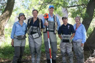
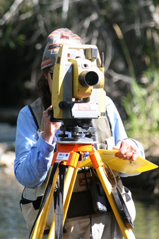
Justice says that one of the key CHaMP efforts involves surveying the current habitat conditions in 26 watersheds across the Columbia River basin, then later resurveying the same sites and monitoring how things have changed. A good deal of that work has traditionally been done using basic “stick and tape” techniques which were both limited in scope and time-consuming.

“Our team is responsible for roughly a 20-mile stretch of Catherine Creek and a 30-mile stretch of the Upper Grande Ronde River upstream of the cities of Union and LaGrande, Oregon,” Justice said. “The salmon populations are severely depleted in these streams, so we feel a real sense of commitment to what we are doing.”

Frustrated with the shortcomings of the usual approach and realizing the scope of what lay ahead for them — potentially another nine years of work — CHaMP representatives contacted Shane Aldrich from the Salt Lake City branch of Rocky Mountain Transit and Laser to discuss alternatives and were soon taking delivery of 15 Topcon DS 205AC total stations.

“The goal of the survey effort is to essentially create a three dimensional map of the channel.”

Casey Justice, Aquatic habitat scientist for the Columbia River Inter-Tribal Fish Commission (CRITFC)

Team Effort

CHaMP crews generally consist of a team of three or four: the total station operator, one or two rod men and one member who measures auxiliary habitat data. The team tackles a particular section of their assigned watershed, first establishing benchmarks, then surveying about a quarter mile of stream per day.

“The goal of the survey effort is to essentially create a three dimensional map of the channel,” said Justice. “At present, Jake Beavis, our rod man, walks through the stream selecting key points — the water’s edge, the deepest point in the channel, any bars or islands, etc. — and Nancy Platt, running the total station, shoots the point. When the day is done, we will have shot anywhere from 800 to 1300 points which will serve as the basis for a decent 3D representation of that section of stream.”

A good portion of the team’s survey work involves shots into heavily brush-covered areas, which could prove problematic for more advanced technology such as GPS or more time consuming for the traditional stick and tape approach. It is, however, ideal for total station work, given ease with which the technology thrives in heavily wooded environments. Platt said she really appreciates the user friendliness of the DS 205AC and the functionality of the MAGNET Field software.

The Full Picture

The Auxiliary Habitat Data Crew mentioned above includes Danielle Horne, working with biologist and crew leader Monica Blanchard. They are charged with, among other tasks: channel classification, monitoring of fish cover, substrate composition, distribution and embeddedness, solar input and water temperature, stream discharge, water chemistry, and site-level human influence.

“All of these are critical to determining how much of a positive impact is being realized,” said Blanchard. “For example, we measure and quantify how much large woody debris is in the stream, the amount riparian vegetation cover in place, and the site’s deep pools, and riffles. Between our data and that of the survey crew, it is a nice snapshot of the watershed as it exists today.”

The real value of the work they do, however, is found in the comparison between current and previous surveys. And that, said Justice, underscores the valuable role the Topcon DS 205AC is playing for CHaMP.

“We are able to gather a huge amount of highly-precise information, then come back to this same spot, tie in to the same benchmarks and evaluate how things have changed: whether there are more pools, if they got deeper etc. In the past, not only was the data lacking much of that precision, it was very hard to quantify the changes that had occurred. This is a huge advantage for us and for the success of the program overall.”