Looking for your apps? Click the account icon in the upper right corner of the page.

Harvesting solar power

Hero Image

High Points and Low Points

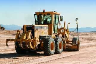
Just outside of Las Vegas, USA, to build off a Bible phrase, one innovative technology is begetting another. There, more than 300-acres (120 hectares) of desert scrubland is being converted into one of the Southwest’s newest solar farms.

When complete and fully online, the facility will be capable of producing 30 megawatts of power, enough electricity to supply 2,500 homes for a year. However, a tight schedule and huge volumes of earthmoving, coupled with dramatic slopes and terrain shifts onsite, raised the degree of challenge to make that happen – a challenge that is being resolved by satellite positioning and a small fleet of GNSS-controlled graders.

Managers at Aggregate Industries (AI), a project subcontractor, knew it would have been almost impossible to tackle the job using traditional survey, layout and earthmoving techniques. And so, with things moving forward let there be light (or at least power).

"We knew going in that this was not going to be a straightforward ‘sheet grading’ job!”

Ryan Baxter, Aggregate Industries foreman

Efficiency in Their Hands

The Spectrum Nevada Solar Farm project was not only a large project, but also was designed to be one of the most efficient in the state. The complete array features 130,000 photovoltaic solar modules and 2,000 tracker rows that have the ability to increase production of electricity at the solar farm by more than 20 percent. According to onsite foreman Ryan Baxter, AI’s work began in December 2012 and has progressed to the point where the site is already generating power.

“We started out by clearing a huge area of desert and scrub brush, created a retention pond and a laydown area, then moved on to the line-up. We knew going in that this was not going to be a straightforward ‘sheet grading’ job. The grading portion divined the terrain into an engineered model that built on the concept of having a high contour that would travel down low into a flow line, then back up to a high spot, over and over so water on the site would drain into these lower flow lines and exit the project site.”

Working through Topcon dealer Nevada Transit & Laser, AI has grown its GNSS-based equipment inventory with Topcon 3D-MC machine control systems for three of its Cat 14H motor graders.

The subtle one to two feet (half a metre) of undulation of the land to which Baxter refers were spaced every 66 feet (20 m), creating 38 rows of high and low points. Creating these features using “traditional surveying and grading techniques would have been a nightmare,” he said. “The Topcon controllers made staking out the poly lines on the slope fast and easy.”

On other solar farm jobs AI’s done, only small amounts of material were cut. But the undulations needed at this job resulted in cuts and fills that ranged from as small as 12 inches to as large as eight feet (30 cm to 2.5 m).

“There’s no overselling the impact those handheld controllers had on this operation,” said Baxter. “Being able to have everything at hand at any given moment made all the difference. We easily halved the production time on that part of the job.”

"Those three blades made the finishing effort fast and efficient – particularly in light of all the slopes we had to deal with.”

Ryan Baxter, Aggregate Industries foreman

Getting to Mass Early

A full array of dozers, scrapers and compactors did the bulk of the heavy lifting on the project, moving more than 700,000 cubic yards (550.000 m3) of dirt and rock; for finish grading, a trio of machine controlled motor graders took over.

“Those three blades made the finishing effort fast and efficient – particularly in light of all the slopes we had to deal with,” Baxter said. “Each operator’s ability to see his onsite position on the cab monitor at all times made a huge difference.”

When confirmation of values was needed – volumes of soil moved in a specific time frame, for example – Baxter said GNSS again provided a solid answer.

“Using a GNSS rover, I can go through and topo an area and save that file; after the area has been cut or filled, I simply create a new surface and compare the two. It lets me know exactly how many yards of extra material we did. That’s a huge positive on any job.”

As onsite foreman, Baxter oversees quality control for AI’s projects – a fairly easy task on most jobs. But doing so on a massive solar farm site is anything but easy. Manning a rod to grade check on a site of that size and complexity can be daunting and, more importantly, time-consuming. To deal with that, Baxter attached a GNSS rover to the roof of his pickup and drove the site checking grades and making corrections as needed.

“It’s been a great solution,” he said. “When I take the rover off the grid pole and place it on top of the truck, the difference in elevation is minimal. So I grab a data collector and drive around getting my cuts and fills, no differently than if I was walking the sit only much faster. I can ride an area that my blade has just finished and know exactly how we’re doing. It’s really kept production levels up. And the technology will continue to benefit us on future projects.”