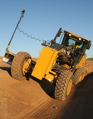
“When we first came on site, this area was basically just scrub land dotted with creosote, palo verde and some mesquite,” said Guevara. “We had to first clear and grub, then we took a blade and ripped the surface so we could pre-wet it. We used a pair of John Deere 672/772 motor graders to cut and maintain the roads, which we actually did at the same time the mass excavation was going on. Doing so, we found, lessened the amount of mass excavation and ramped up production.”
A look around the expansion site revealed very few grade stakes, a telltale sign that GNSS technology was at work. Guevara said that he had prior experience with GPS equipment and systems and knew — particularly as a new company — that he wanted to put it to use at the Cemetery project.
“I first used GPS when I was with a company back in 2000,” he said. “So I know the tremendous boost in productivity it can give, and felt that I had to have it on this project.”
Critical Support
While Guevara may have felt at home with machine control and other such solutions, a couple of his men were new to the technology and had to have a crash course in working within a GNSS environment. Enter Jordan Daughters, account manager for RDO Integrated Controls’ Gilbert, Arizona office.
“As we do with most customers who are new to this type of technology, we spent a lot of time at the outset helping JAG’s team get control established, walking personnel through the training — basically just getting them up to speed. One of the company’s guys was very new to GPS, so he needed to have a knowledge base to get him through the times when we are not out here. However, we don’t mind because that’s something that’s beneficial for both them and us. And to their credit, JAG’s people picked up on the technology quickly, testimony to both their ability and Topcon’s user-friendly design.”
On the equipment side of the equation, RDO outfitted JAG’s two motor graders with Topcon 3D-MC2machine control in a twin-antenna, single-mast configuration. Guevara’s decision to place his faith in the GNSS solution put his company at what Topcon calls the “Intersection of Infrastructure and Technology,” a conceptual crossroads where Topcon helps industry professionals best meet growing infrastructure demands through technological innovation. The upshot to stopping by that metaphorical intersection is an increase in both productivity and profitability
A Channel Runs Through It
Though the majority of the cemetery expansion site is relatively flat, the retention ponds and drainage channel were areas that could have proven problematic, had they been done using traditional survey methods. Guevara said there was a limited amount of initial staking done, but it was for reference only, to ensure the accuracy of the modeling and surfaces.
“This channel is being shotcreted which meant our tolerances were extremely tight,” he said. “We needed to keep things within ¼” which would have been a real headache without the Topcon solution. The base of the 1,350’ long channel was 12’ wide — just wide enough to fit the John Deere machine — and the sides were graded at a 2:1 slope. The operator was able to concentrate on what he was doing without having to reference grade stakes or stop for grade checks. It made that part of the job a breeze.”
The company got similarly impressive results on the pair of retention ponds — one of which was just under an acre in size. Guevara said being able to do so much detail work with the Topcon system dramatically ramped up production. “This is easily 70% faster than doing things ‘old-school,’” he said. “Having the blades equipped with GPS gave us the confidence to walk away each day knowing that the numbers were there.”
Honored by Service
In addition to the site work mentioned above, JAG was also contracted to excavate foundations for a pair of columbarium courts, structures with built-in niches to house urns with cremains. Guevara once again turned to GNSS to streamline that effort, specifically a Topcon excavator system.
“The soil on this site is very expandable, so we had to over-excavate and put in select fill, material that keeps the foundation from shifting,” he said. “Because of the GPS system on that machine, the operator knew exactly how far down he had to go; there was no questioning or verifying depths — that was a nice solution for us.”
The year 2017 was one in which JAG opted to invest in technology. In addition to a Topcon HiPer V receiver and several Topcon FC-500 data collectors, they purchased six complete GNSS-based machine control systems. This year they are looking at additional machine purchases to meet what is forecast to be more than double 2017’s numbers.
“We are excited for the growth that lies ahead and the projects already on the books,” said Guevara. “The National Cemetery, however, was a unique project. Out of respect, we would stop work whenever a service was being held, and that just makes one realize the sacrifices made by so many laid to rest in this cemetery. The new expansion will make room for more of these heroes— I felt honored to have been a part of it.”


