Looking for your apps? Click the account icon in the upper right corner of the page.

Network brings ‘life’ to bathymetric survey boat

Hero Image

Network brings ‘life’ to bathymetric survey boat

Real-time, accurate, xyz positioning is crucial to most all aspects of surveying, and none more so than bathymetric surveying utilizing the state-of-the-art, remotely controlled, bathymetric survey boat technology, known as the unmanned surface vessel (USV) “Kingfisher.”

Kingfisher is loaded with survey-grade sonar, an inertial measurement unit, a remote controller Wi-Fi system, and survey-grade RTK GPS. On shore, the survey data is received by the remote control operator in real time with the map and data view screens on a laptop.

Hunt Surveys Inc., an Ontario land surveyor firm, acquired Kingfisher from Clearpath Robotics in 2014, in order to expand into the growing bathymetric survey marketplace. At the time of the Kingfisher build-out for Hunt Surveys, the selected Topcon and Sokkia GNSS hardware was chosen for the ease of integration into the custom Clearpath controller software, and with the bathymetry software by Hypack. The TopNETlive network was also chosen for the extensive coverage in Ontario, including many remote locations of the bathymetric surveys.

The real-time xyz GPS data from the TopNETlive network makes Kingfisher “live” to the on-shore, remote controller operator. The Hypack bathymetry software on the operator’s laptop allows for pre-planning routes, density of coverages, and instant monitoring of the readings and their quality. Real-time xyz GPS map data allows the remote operator to drive Kingfisher exactly along the pre-planned routes, and to make the coverages required instantly. Areas of weak data coverage can be identified and re-measured at a time when it is easy to do so.

Bathymetric survey boat

Kingfisher

The real-time aspect of the remotely controlled bathymetric survey boat is highlighted in the three key success factors of Hunt Surveys business model for bathymetric surveys:

  1. Accuracy: survey grade, more and better data, planning and executing the project requirements
  2. Safety: remote control minimizes risk to staff, and all stakeholders
  3. Economy: faster, more efficient, lower-cost quality data collection over larger areas Going into year three of operation, Hunt Surveys has seen 100% growth per year in bathymetric surveys revenues. The Kingfisher system technologies, including Topcon and Sokkia GPS hardware, and the TopNETlive network, have performed exceptionally well.

Grand River Conservation Authority

Grand River Conservation Authority

Bathymetric survey of the Grand River at Dunnville Dam

In 2015, Hunt Surveys Inc. was contracted by the Grand River Conservation Authority (GRCA) to provide a  bathymetric survey of the Grand River at the Dunnville Dam. An engineering sub-consultant, KD2 Consulting, was also engaged by Hunt Surveys to assist in project management and final deliverables.

The project extents ranged 10 kilometers, noting that the river is over 0.5 kilometers wide at the Dunnville Dam. The scope further included several tributaries with three other smaller dams. The purpose of the bathymetric survey was to confirm and clarify possible sediment build-up at the dam and to enhance the hydraulic model for the river at the dam.

There had been some visible physical concerns of backed-up ice flows and flooding up-stream from the dam and there was a need to review actions and alternatives. GRCA had existing base survey lines, as were measured with a rod from a boat in approximately 1980. The horizontal and vertical references were plotted with hard copy maps available at the time.

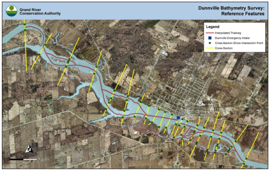
Hunt Surveys with the Kingfisher was to retrace those old survey lines (to determine the original quality or changes) and then densify and add to the data. Within the 10 km extent, the additional data included areas of 20 meter transects (sections), a 1 – 3 meter offset run from edge of water, running the thalweg (deepest points) and streamlines, and measuring some edge of water points separately from the boat.

Prior to fieldwork (launching of Kingfisher), the Hypack software was loaded with old survey lines and also the pre-planned transect lines to travel for the entire extents. Site reconnaissance was undertaken to review safety concerns/plans, launch points and crew accommodations for the anticipated eight to 10 days of fieldwork. Due to the dams and cold water, safety was a paramount issue for the field staff.

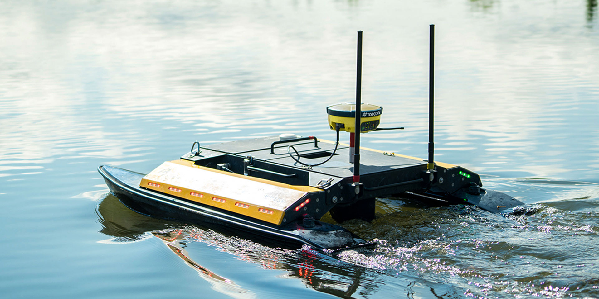
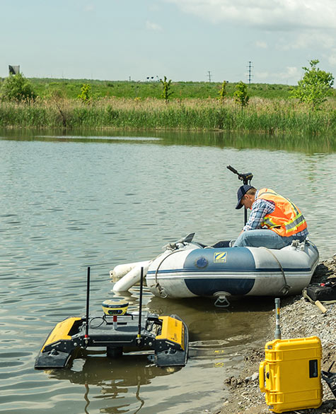
While Kingfisher is unmanned, there was a need to work with a support boat due the large extents (10 km) of the project. While the RTK TopNETlive signal provided full coverage, the system Wi-Fi could only extend approximately 300 meters. Similarly the shoreline was mostly privately owned lands and very difficult terrain, thereby not allowing the Kingfisher remote operator to work from shore.

For the long stretch runs, Kingfisher was assisted in propulsion speed by lashing to the support boat. This allowed for an increase in speed from approximately 1 meter per sec to 2 meters per sec. In detail areas close to the shoreline or edge of water, and in areas near the dams — Kingfisher was remotely controlled by the operator from the support boat.

As the data was shown live on the laptop and Hypack software screens, full coverage of the project plan was achieved.

Once fieldwork was completed, the raw data files were again separately processed in the office version of the Hypack software. Data was filtered for weak signals, and outliers, and then parsed for unnecessary density by another internal software tool. The processed data was then imported into terrain modeling software and was reviewed for quality control. The final deliverables were a points file and CAD file to the client.

Generally, a successful project for all—with client satisfaction and meeting budget — Hunt Surveys key success factors were achieved: accuracy, safety, economy.