Interstate Trafficking
The goals and vision for the project referenced above are many. The most pressing is to ease the gridlock that has become commonplace in that area. Driven by steady development, traffic volumes through Little Rock’s northeast suburbs have risen steadily to more than 75,000 cars per day.
However, widening the $79 million Highway 67 corridor from Jacksonville through Cabot, as this project entails, also provides a key segment for a much larger future plan: to link an additional 120 miles of Highway 67 in Arkansas with Interstate 57, which currently stretches from southeast Missouri to Chicago. In fact, many of those miles of Hwy. 67 projected for improvement, already bear signs reading “Future I-57.” The long-term vison is one in which the new road allows interstate access in a part of the state where none currently exists.
Lessons Learned
A major component of Weaver-Bailey’s plan for the Jacksonville project was largely dictated by success from a previous, similar job, according to Jamie McAnelly, the company’s project superintendent.
“A while back, around 2012, we did a stretch of Highway 67 north of here,” he said. “On that job we built six miles of four-lane road between the towns of Cash and Hoxie, and one of the cornerstones of the project was the use of millimeter-grade GPS on almost every major facet of the job, from trimming to building a layer of cement stabilized crushed stone base (CSCSB) to adding a bond-breaker to the concrete paving itself.”
At that time, McAnelly admits, he was new to GPS of any kind, so when the local Topcon dealer, came out to set up the company’s trimmer, paver, and motor grader, McAnelly made certain he absorbed as much of the technology as he could and was able to train his crew on that project and subsequent work as well.
“The performance — and the level of support — we got from the Topcon Millimeter GPS solution throughout that Cash job was so impressive we knew it would have to be a part of all projects like these moving forward,” he added. “So using it on the Jacksonville segment was a no-brainer.”
A Stabilizing Force
Because that particular section of Highway 67 had been serving the area since the 1960s, nearly six decades of wear had taken its toll — both at-grade and below. Testimony to the truly unreliable nature of the subgrade material was the degree of stabilization needed to bring it up to spec. According to McAnelly, it was initially estimated that 200 tons of stabilized soil would suffice.
“We’ve done over $1.2 million in stabilization so far — more than 2,000 tons of material — and we’re far from done,” he said. “On the north end of the project there is a small section that had a decent shale base and didn’t need any help, but otherwise we literally had to stabilize it all, including some of our fills prior to bringing it up with the shale. There were some areas that we tried to blanket with a 3-foot bridge lift of aggregate and the subgrade was just so bad it wouldn’t hold it. It was a real mess down there.”
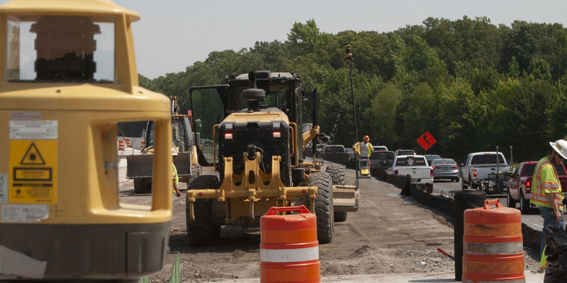
To deal with those conditions, McAnelly’s crew did 5% cement soil stabilization. Using both a Bomag 454R and Cat RM500, they mixed material to a depth of about 18 inches, then essentially capped it with a 6” layer of Cement Treated Base (CTB). In most cases, the biggest challenge dealing with CTB is trying to get it cut to grade before it gets too hard. However, since Weaver-Bailey drew upon the benefits of Topcon Millimeter GPS for its trimming operation, that was never the case.
Productivity With All the Trimmings
Weaver-Bailey’s trimming efforts averaged taking the CTB down an average of .1 of a foot. Even with that modest depth, the volume of material generated was impressive.
“Trimming alone yielded about 10,000 to 13,000 cu. yds. of soil that we removed,” said McAnelly. “But this was one of the areas in which having the Millimeter GPS working for us paid off in a big way. Without it, we would have needed a crew setting string line continuously in front of the trimmer. The Topcon solution allowed us to eliminate the need for that string crew — freeing them up to work in other areas onsite.”
The Millimeter GPS solution to which McAnelly refers starts with a 3D digital design model which is loaded into the machine of choice, in the case above, a GOMACO Model 9500 trimmer. Then, rotating laser transmitters located in the work area generate a laser zone which the 3D system on the trimmer accesses to verify elevation and set the necessary depth for material removal to get to the desired grade.
“As we expected, Millimeter GPS made a huge difference for us,” said McAnelly. “Not only did it allow us to maintain the ±.25 inch tolerances required here — it actually kept us within .01 and .02 of a foot — we were able to complete the entire trimming operation in half the time it would have taken using string line. That’s a huge benefit for us.”
With the challenging subgrade demands met, the Weaver-Bailey team set to work laying down a 1-inch layer of bond-breaker, then completed the process with a 12-inch layer of cement treated base. By project’s end, more than 100,000 cu. yds. of concrete will have been placed.
Workforce Challenges
Given the wide use of GNSS solutions on a typical Weaver-Bailey jobsite — at Jacksonville alone, in addition to the Millimeter GPS, the company is also relying heavily on equipment running Topcon 3D-MC2 and 3D-MCMAX machine control for earthmoving and rough grade work — one would think people would be beating down the doors to join their team. That’s not really the case, said McAnelly.
“It’s often a challenge for us to find good employees, and I know that this is the situation industry-wide,” he said. “Part of the problem is perception: people don’t really know what today’s construction job involves, how much technology plays a role in it. I think technical and vocational schools need to do a better job of promoting training for construction in the 21st century. There is a whole generation of kids out there who are already comfortable with technology and would take well to things like GPS machine control. We just have to guide them in our direction.”
Tech as a Stepping Stone
For their part, Weaver-Bailey is encouraging its own workforce — both men and women — to step up and use technology as a means of advancement.
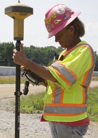
“We have a fairly ‘green’ crew right now, but we also have some people who see and appreciate what GPS brings to the job,” he said. “Marty Toddy, for example, has been with us for about six years. She started as a laborer, then became a grade checker, and today she’s one of my best layout people. She knows how to burn in control points, how to take topo shots, the whole package. I’d love to have more like her.”
The Jacksonville segment of Highway 67 is slated for an April 2019 completion. When it wraps up, McAnelly said he will look at it with a sense of accomplishment — as he does with all the Weaver-Bailey projects he’s supervised.
“There’s no doubt I take a lot of pride in what we do out here,” he said. “As a youth pastor, I recently brought my kids down to Verizon Arena for Winter Jam. During the ride to the arena, I got on the bus’s PA system and called out all the jobs we’d done along the way. What can I say? I like what we do.”